 Skipper
Prepare
•All boatersTides and Currents Explained: A Sailor's Guide
Understand tides, tidal range, tidal coefficients, tidal streams and slack water. Learn how to use tide tables and current forecasts to plan safer sailing trips.
Tides and Currents Explained: A Sailor’s Guide
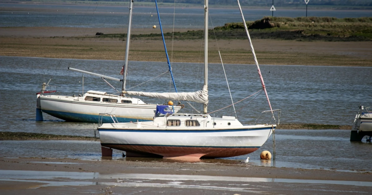
Tides and currents can make the difference between a straightforward sailing passage and a difficult one. They affect the depth of water beneath your keel, your speed over the ground, your arrival time and the conditions you may encounter around headlands, narrow channels and harbour entrances.
The key distinction is simple: tides change the height of the water, while currents move the water horizontally. They are related, but they are not interchangeable, and their timing does not always match.
This guide explains how tides work, how to read tide tables, what tidal coefficients mean, and how to account for currents when planning a sailing trip.
What is the difference between a tide and a current?
Tides: the rise and fall of sea level
Tides are the periodic changes in sea level caused primarily by the gravitational attraction of the Moon and the Sun, combined with the motion of the Earth-Moon system.
At a particular location, the water level rises towards high tide, also called high water, and falls towards low tide, or low water.
The timing and size of these changes vary with location. Coastline shape, seabed depth and local geography influence how the tide behaves.
Currents: the movement of water
A current is the horizontal movement of water, described by its direction and speed.
Tidal currents are associated with the rise and fall of the tide. Water may flow into bays and estuaries as the tide rises and out again as it falls. These are often called flood and ebb currents.
Not all currents are tidal. Wind, differences in water density and larger ocean circulation patterns can also move water.
For sailors, the distinction matters because tide tables primarily describe water levels and their timing, while tidal stream tables or current atlases describe the direction and speed of water movement.
Understanding high tide, low tide and tidal range
Three terms are particularly useful when planning a passage.
- High tide (high water): The time when the sea reaches a local high water level during a tidal cycle.
- Low tide (low water): The time when the sea reaches a local low water level.
- Tidal range: The vertical difference between high water and low water.
For example, suppose a location has a predicted high-water level of 4.8 m (15.7 ft) and a low-water level of 1.2 m (3.9 ft), both expressed relative to the same chart datum.
The tidal range is:
4.8 m − 1.2 m = 3.6 m (11.8 ft)
The tidal range is therefore 3.6 m (11.8 ft).
The range varies over the lunar cycle and between locations. Some places experience relatively small changes in sea level, while others experience much larger ones.
Spring tides and neap tides
Tidal ranges generally follow a cycle associated with the relative positions of the Moon, Earth and Sun.
Spring tides occur around new and full moons, when the solar and lunar tidal effects reinforce one another. They tend to produce a larger tidal range.
Neap tides occur around the first and third quarter moons, when the effects partly counteract one another. They tend to produce a smaller tidal range.
Despite the name, spring tides do not refer to the season. They describe the part of the tidal cycle with a larger range.
A larger tidal range can mean more water over a shallow area at high tide, but it can also be associated with stronger tidal streams in some locations. The relationship between tidal range and current speed depends on local geography and must be checked using appropriate current information.
What is a tidal coefficient?
In France, sailors often use the coefficient de marée as a convenient indicator of the expected size of the tide.
A higher coefficient generally indicates a larger tidal range, while a lower coefficient indicates a smaller one.
For French mainland ports on the Channel and Atlantic coasts, coefficients are commonly published alongside predicted high and low waters. They are not a universal international system, and they should not be confused with the actual height of the tide at a particular moment.
A tidal coefficient does not tell you directly:
- The exact water depth beneath your boat.
- The current speed at a particular point.
- The precise time of slack water.
- Whether a passage is safe.
Use it as context, not as a substitute for local tide tables, charted depths and tidal stream information.
How to read a tide table
A tide table provides predicted high and low water times and heights for a specific location and date. Depending on the source, it may also include tidal coefficients or additional water-level predictions.
Here is an illustrative example:
| Event | Time | Predicted height |
|---|---|---|
| Low water | 05:45 | 0.8 m (2.6 ft) |
| High water | 11:55 | 5.2 m (17.1 ft) |
| Low water | 18:10 | 0.9 m (3.0 ft) |
These values are hypothetical and are included only to demonstrate how a table works.
In this example, the predicted tidal range between the morning low water and high water is 4.4 m (14.4 ft).
When consulting a real tide table, check the following.
1. Confirm the location
Tide predictions are location-specific. Times and heights at one port may differ from those at a nearby harbour or exposed coastline.
Use the appropriate reference port and check any published corrections for the location you are navigating to.
2. Check the date and time zone
Make sure you are using the correct date and time convention. Published tables may use UTC or local civil time, depending on the source.
An incorrect time zone or daylight-saving adjustment can lead to mistakes when planning a departure or arrival.
3. Understand the height reference
Tide heights are measured relative to a reference level, or datum. Nautical charts also use a chart datum for soundings and drying heights.
Do not assume that a tide height is the same as the depth of water beneath your keel. You need to combine the predicted tidal height with the relevant charted depth and understand the datum used by each source.
4. Allow for real-world differences
Tide tables provide predictions, not guarantees of the exact water level.
Atmospheric pressure, wind and other conditions can cause the observed water level to differ from the prediction. In areas with strong local effects, the difference can be operationally important.
For French waters, the SHOM tide prediction portal provides official tide predictions for supported French ports. Elsewhere, use the relevant national hydrographic office or official local source.
How to calculate the available water depth
Tides are especially important when sailing into shallow anchorages, navigating estuaries or entering ports with depth restrictions.
A simplified calculation is:
Available water depth = charted depth + tidal height above chart datum
For example, suppose a charted location has a depth of 2.0 m (6.6 ft) at chart datum, and the predicted tide height above that same datum is 1.5 m (4.9 ft).
The estimated water depth is:
2.0 m + 1.5 m = 3.5 m (11.5 ft)
If your boat draws 1.8 m (5.9 ft), the nominal clearance beneath the keel would be:
3.5 m − 1.8 m = 1.7 m (5.6 ft)
This is a simplified illustration, not a navigation calculation for a real passage. You must use the correct charted depth, tidal prediction and vertical datum, and allow for uncertainty, squat where relevant, wave motion and an appropriate safety margin.
For areas that dry at low water, charted drying heights require particular care. Do not treat them as ordinary positive depths.
Why under-keel clearance matters
Under-keel clearance is the vertical distance between the lowest part of your boat and the seabed.
When planning a passage, consider:
- The vessel’s actual draught, including any relevant loading or configuration changes.
- Charted depths and drying areas.
- Predicted tidal height at the time you expect to pass.
- The accuracy and limitations of the available information.
- A suitable safety margin for the location and conditions.
The water level will continue to change while you sail. A route that has sufficient depth at high water may not be suitable later in the tidal cycle.
What are flood, ebb and slack water?
Tidal streams describe the horizontal movement of water associated with the tide.
Flood current
A flood current generally refers to water flowing towards the land or into an estuary or harbour. The precise direction depends on local geography; it is not always simply towards the nearest shore.
Ebb current
An ebb current generally refers to water flowing back out of an estuary, bay or harbour towards the sea.
Slack water
Slack water is a period when the tidal current becomes weak as it changes direction.
It can be useful when planning a passage through a narrow channel or other area affected by strong tidal streams. However, slack water is not necessarily the same moment as high or low tide.
The time of slack water varies with the location and local tidal dynamics. Always check tidal stream predictions for the area you intend to cross.
How currents affect your sailing speed
A tidal current can increase or reduce your speed over the ground.
Your boat’s speed through the water is the speed at which it moves relative to the surrounding water. Speed over the ground is the speed at which it moves relative to the seabed.
A current changes the relationship between the two.
For example, suppose your boat makes 5 knots through the water.
- With a 1-knot following current, your speed over the ground may be approximately 6 knots.
- With a 1-knot opposing current, your speed over the ground may be approximately 4 knots.
These examples assume the current is directly aligned with your course. A current from another direction also affects your course over the ground and may require you to compensate.
The practical consequences include:
- Longer passage times when sailing against a current.
- Faster progress with a favourable current.
- Greater difficulty holding a planned track when the current sets across your route.
- Changes in arrival time that affect tidal access to a harbour or anchorage.
When planning a route, account for currents along individual legs rather than assuming the boat will maintain the same speed over the ground throughout the passage.
Why wind against tide can create difficult conditions
When wind and tidal current flow in opposing directions, waves can become steeper or more closely spaced in some circumstances.
This effect can be especially important near headlands, bars, shallow areas and narrow channels, where the current may accelerate or interact with the seabed.
A strong opposing current can also reduce progress and make steering more demanding.
However, wind against tide does not always produce dangerous conditions. The outcome depends on wind strength and duration, current speed, water depth, wave conditions and local geography.
Before a passage through an area known for strong tidal streams, consult local sailing directions, current atlases and marine forecasts. Consider whether the timing of the passage can be adjusted to avoid the most challenging conditions.
For more on wave height, swell and wave period, see Sea State Explained.
How to plan a sailing passage around tides and currents
Tidal planning should be part of your overall passage plan, not a separate check completed only before departure.
Step 1: Identify tidal constraints
Check whether your route includes:
- Shallow channels or areas with limited depth.
- Harbours with tidal access restrictions.
- Strong tidal streams around headlands.
- Narrow passages or estuary entrances.
- Anchorages where depth changes significantly.
Mark any places where the available water depth or current conditions may determine your timing.
Step 2: Check predictions for the relevant locations
Consult tide tables for departure, arrival and any intermediate locations where water level matters.
For areas with significant currents, consult tidal stream tables or current atlases as well. Tide heights alone do not provide enough information to determine the direction and speed of the current.
Step 3: Estimate your passage time
Estimate how long each leg will take, taking into account the boat’s expected speed through the water and the predicted current.
Do not rely exclusively on a single average speed if current direction and strength vary substantially along the route.
Allow additional time for manoeuvres, reduced visibility, changing wind or other delays.
Step 4: Check the arrival window
If your destination has a shallow entrance or another tidal constraint, estimate your arrival time and the predicted water level at that moment.
Plan an alternative if you are delayed or conditions change. Do not assume you will arrive exactly at the planned time.
Step 5: Review the complete weather picture
Tides and currents interact with wind and waves. Check the marine forecast for the entire route, including the time you expect to pass through exposed or constrained areas.
The guides How to Plan a Sailing Trip and How to Plan a Sailing Route cover the broader passage-planning process.
Step 6: Reassess underway
Actual speed over the ground may differ from your estimate. Monitor your position, progress and conditions, and revise your plan when necessary.
If the passage is taking longer than expected, reassess the arrival window and the suitability of the next section of the route.
Common mistakes when interpreting tides
Avoid these frequent errors:
Assuming high tide means slack water. The current may turn before or after high or low water, depending on the location.
Using a tide table from the wrong port. Nearby locations can have different times and heights, and local corrections may be necessary.
Treating the tidal coefficient as a current forecast. A coefficient indicates the expected tidal range in the system where it is used. It does not directly provide current speed or direction.
Ignoring the reference datum. Tidal heights and charted depths must be interpreted relative to compatible reference levels.
Assuming predicted water levels are exact. Weather and local conditions can cause the actual water level to differ from the prediction.
Ignoring the current when estimating arrival time. Speed over the ground can differ substantially from speed through the water.
Planning only for departure. Conditions at arrival and at intermediate points can be just as important as the conditions at the start.
Record tidal conditions in your sailing logbook
A sailing logbook can help you build a record of the conditions encountered on previous passages.
For a trip affected by tides or currents, consider recording:
- Departure and arrival times.
- Positions and locations where current was particularly noticeable.
- Predicted tidal height and observed water-level conditions, if known.
- Current direction and estimated speed, if available.
- Changes in speed over the ground.
- Delays or route changes caused by tidal conditions.
- Any observations that may help with future planning.
Keep estimates distinct from measured or forecast values. A note such as “strong adverse current near the headland; progress slower than expected” can be more useful than an unsupported numerical estimate.
Skipper helps you keep a digital record of sailing trips, including GPS tracks, routes, distance, duration, speed, locations, notes and photos. Reviewing your trip history can help you revisit where you sailed and reflect on the conditions and decisions associated with each passage.
Discover Skipper and build a consistent record of your time on the water.
Tides and currents checklist
Before leaving, use this checklist as part of your passage plan.
- Check tide predictions for the departure and arrival locations.
- Confirm the date, time zone and reference datum.
- Identify shallow areas and any tidal access restrictions.
- Calculate expected water depth where clearance is critical.
- Check tidal stream predictions for strong-current areas.
- Identify whether the current will help or hinder each leg.
- Consider wind-against-tide conditions and local hazards.
- Estimate arrival time with current and possible delays in mind.
- Identify an alternative route or place of refuge.
- Reassess the plan if conditions or progress differ from expectations.
Frequently asked questions
What is the difference between a tide and a current?
A tide is the periodic rise and fall of sea level. A current is the horizontal movement of water. Tidal currents are associated with the tides, but their timing and direction depend on local conditions.
What is tidal range?
Tidal range is the difference between high-water and low-water levels at a particular location during a tidal cycle.
What does a high tidal coefficient mean?
In the French system used for relevant Channel and Atlantic ports, a high coefficient indicates a larger expected tidal range. It does not directly indicate the speed of the current or the depth at a specific point.
Does slack water always occur at high tide or low tide?
No. Slack water is when the tidal current becomes weak as it changes direction. It may occur before or after high or low water, depending on the location.
How do I know whether there is enough water for my boat?
Use the relevant nautical chart, predicted tide height, your boat’s draught and a suitable safety margin. Make sure you understand the chart datum and the reference used for the tide prediction. Account for uncertainty and local conditions.
Where can I find official tide tables?
In France, the SHOM provides official tide predictions for supported French ports through its tide prediction portal. In other countries, consult the relevant national hydrographic office or official local source. Use dedicated tidal stream information where current speed and direction matter.
Final thoughts
Tides and currents affect different parts of your passage plan: tides determine how water levels change, while currents influence how water moves and how quickly your boat progresses over the ground.
Check both when depth, timing or current strength matters. Use local predictions, understand the relevant reference levels, allow for uncertainty and reassess your plan as conditions evolve.
Recording what you experienced in a sailing logbook can also help you review previous trips and make more informed decisions on future passages.
Remember your days at sea
Skipper is a ship’s log app for sailboats and powerboats, available on iPhone and iPad. It records every trip with GPS and keeps your whole sailing history in one searchable logbook. Free for your first three trips.

Keep reading
Beaufort Wind Force Scale
Understand the Beaufort scale from force 0 to 12, with wind speeds in knots and km/h, sea conditions, practical sailing advice, and guidance for interpreting marine forecasts.
All boaters
How to Plan a Sailing Route
Learn how to plan a sailing route using nautical charts, waypoints, distance calculations, weather forecasts, tides, and alternative destinations.
All boaters
How to Plan a Sailing Trip
Learn how to plan a sailing trip, from choosing your destination and checking the weather to preparing your boat, crew, route, and backup plans.
All boaters